
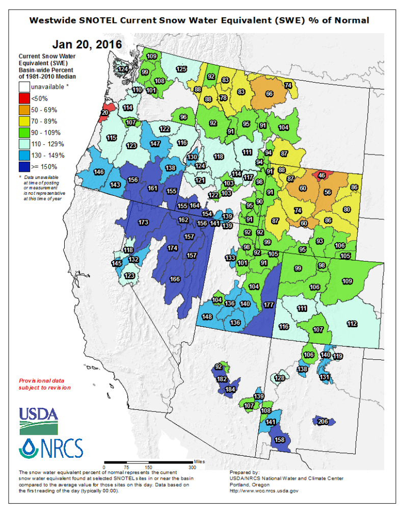
Idaho panhandle, western Montana and central Wyoming could use some more; lots of time to boost those numbers. Compare to last year
Regards,
Scott
Idaho panhandle, western Montana and central Wyoming could use some more; lots of time to boost those numbers. Compare to last year
Regards,
Scott
Scott,
I have been keeping an eye on our snow levels up here in the northwest. My two favorite rivers are not getting the snow packs that I would like them to get. In eastern Washington, the Yakima River only has 75% of normal this year compared to 101% last year. Over in Montana, my favorite river is in the western part of the state, the Clark Fork River. The three drainage basins that feed it average out at only 81% of normal compared to 86% last year. Not the greatest but for sure not the worst it has been in years past. We take what we get and make the best of it.
Larry —sagefisher—
Well, Larry… I been watching too. In my neck of the woods, extreme N.E. CA high desert, we’ve gotten more snow this year than the past 5 or so put together. It has remained quite cold since the first snow in Dec., so it’s soaking into the aquifer slowly, as it should. Been getting medium to heavy rain this past week, and below 5000ft it’s melting fast. Moving in the right direction, though. We’re gonna need a few consecutive wetter years to heal things properly, though. One concern I have is the many remote ponds and lakes that used to support good populations of bass and catfish have gone bone dry several summers in a row. I don’t know who originally stocked these waters, but somehow I think it was not the Fish & Game boys. Regardless of that, at least a few generations of fisherman got the bug, and often put food on the table from these waters… Now, most of them have nothing but mosquitoes. Is there any hope they will be restocked once normal water levels stabilize, I wonder. … Dan ModocDan
Dan,
That is where local fly clubs, and other sports fishing type clubs can join forces with organizations like the Int. Federation of Fly Fishers and Trout Unlimited so sort of push the local game departments into a decent restocking program for ponds, lakes and some streams (like the ones that went dry and had a total die off of fish. The Northern California Council of the IFFF should be able to help out as can local and regional and state chapters of TU.
Larry —sagefisher—
Thanks for that info., Larry… Funny, my mind doesn’t just jump right to reaching out to groups like those… I guess I haven’t been retired long enough…my brain still thinks like I got work every day, and a career… I gotta get fishin’ up there on my priority list, I guess ! Haha!
I take it the white area in northern Arizona and New Mexico is from a lack on information, not that it doesn’t snow on that side of the stateline.
Well, North-western Montana just got a new batch of snow Sunday into Monday, broke a lot of state records…
Sagefisher, The local DNRs might not be to enthused about restocking those ponds until they know they’ll stay filled for several years. It takes a few years for a good population of bass and bluegills to become established in a pond when you’re starting from scratch.
Looking decent; a lot more blues and greens.
Regards,
Scott
I live up in NW Montana and we are looking at the most snow since 1996 still on the ground.
That’s great! Eureka!
good snow year. our fish will like it.
I recently moved to Missoula, MT. Any idea about when runoff will start?
Thanks,
Randy
Randy -
A lot depends on the weather, obviously, when it starts to warm up, and how warm it gets.
Although I’m in PA now, and don’t normally get to MT until May, I’m often there before the runoff begins in earnest on the Yellowstone (runoff can begin near the end of May, or beginning June). I am just south of Livingston. That timing may differ somewhat from where you are, and may differ from one rivershed to another. (I see the weather there this week is getting too warm already for this time of the year, and the Yellowstone water flow is trending upwards this week, and is considerably above normal for this time of the year - but then so is the snowpack considerably above normal, as is YTD precipitation.)
As a starting point, you could go to a USGS water data website, and look back over time to see when the runoffs have begun for prior years for any specific rivers you’re interested in. Here’s one place you can start to get this data: https://waterdata.usgs.gov/mt/nwis/rt There may be other places that have this data also.
John
Randy,
John is right. The normal is a heavy runoff in May and into June. But, the Clark Fork River is already doing some heavy runoff flows. The normal flow for this time is year in the St. Regis, MT area is 3,690 cfs. Five days ago it was at 7,000 cfs but still fishable. This morning it is at 15,800 cfs. That is not a good flow for fishing and can be dangerous. I usually like to hit the Clark Fork in early April for some Skwalla action, but not this year. I suspect the flow rates will yo-yo up and down on almost a daily basis until the main runoff is finished in mid to late May or very early June. Mother Nature will determine that.
But, you are living in the center of a fantastic fishing area. Way to go.
Larry —sagefisher—
Here is the USBR (bureau of reclamation) web site for the north west. https://www.usbr.gov/pn/hydromet/select.html
I post updates for Yellowstone and SW Montana regularly at http://reports.parksflyshop.com. Will go to weekly updates with the next. Most recent posted today.
Wally -
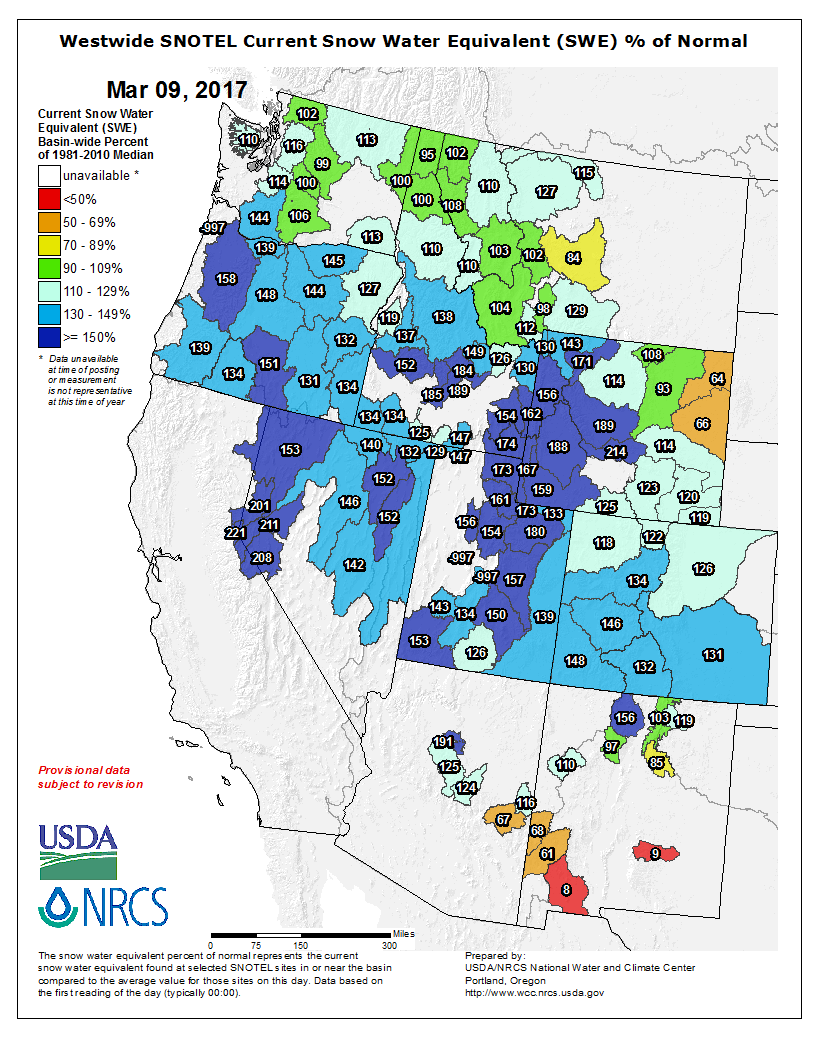
Your most recent report says “Overall snowpack numbers are still strong. The most important basin in the PFS operations area, the Upper Yellowstone Basin in Yellowstone Park and northwest Wyoming, is at 137%.”
The NRCS reports that I look are now showing the Upper Yellowstone’s snowpack (snow water equivalent as a % of the historical median) at 117%. - still not bad, but going down everyday, as you say, due to warmer than normal weather for this time of the year.
Are you looking at different reports for your 137% number, or is it 117%?
I don’t know if you look at the locations of the specific snow gauges that are included in the reported Upper Yellowstone snowpack numbers, but if you do you’ll have seen there are a handful of these snow gauges that are in the Boulder and Shields river watersheds, and don’t directly effect the Yellowstone’s waterfowl through the Park, Gardiner, and upriver of Livingston. Those areas presently are reporting lower than normal snowpacks.
Also, I’ve noticed that one other snow guage that was normally included in the Upper Yellowstone’s snowpack numbers, the Two Ocean Plateau snow guage near the southern end of the Park, has not been reporting snowpack since March 1, when I believe there was a major snowfall in the area. There was (and probably still is) a LOT of snow there, so including that guage in the reports might increase the reported snowpack percentages. (I believe that guage is actually in the Snake River watershed, but I’m told by NRCS that it is believed there is a comparable snow in that area that would effect the Yellowstone river.)
This is the map I generally use. The 137% number is for the Yellowstone Basin in Wyoming, essentially the park section of the Yellowstone basin, which is responsible for most of the water in our operations area. Even east of Livingston, the park water is still more important, though if snowpack is low the irrigation drawdowns can hurt the lower river (occasionally we have more water at the Corwin Springs gauge near Gardiner than E of Livingston). This page can build detailed reports for whatever drainage you want.
I think the Two Ocean Plateau gauge is probably buried. Even before it stopped posting it was only posting for a couple hours in late afternoon, so I think the solar panels were gradually getting covered. The Thumb Divide gauge is also still very deep, and the Snake drainage just over the hill S of the park is also deep. That’s why I predict that the upper Yellowstone from the lake to the falls will have comparatively the highest flows of anything this year. The NE Entrance gauge is shetting snow fast, so the Lamar might be near-normal or even low overall, though Red Lodge Mountain extended their ski season so I think the higher elevations of the Beartooths and Absarokas are still buried.
Thanks, Wally. I understand the difference now between the two numbers. I had been looking at the Montana snotel reports for the Upper Yellowstone (comprised of 23 snow gauges, which is basically from Big Timber upriver) whereas your 137% is, as you say, the Yellowstone (Park) basin, or everything upriver from Gardiner.
I see that the 137% number is comprised of 13 separate snow gauges which are, I believe, all located in the Park. These same 13 snow gauges are also included in the snotel reports called the Upper Yellowstone watershed, plus another 11 gauges farther downriver.
Interestingly, if I’ve identified all of the gauge locations correctly, there are no gauges to measure the snowpack between Canyon and the Northeast Entrance, all the way downriver to Livingston (except for the Shower Falls guage, which is actually in the Hyalite drainage, but they include it in the Upper Yellowstone snowpack reports).
