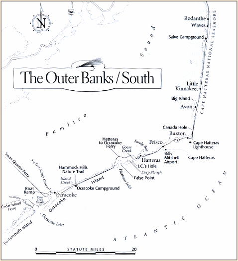
Whenever saltwater fishing in North Carolina is mentioned,
most anglers think immediate of the Outer Banks, which span
Currituck, Dare, Hyde, and Carteret Counties. Stretching
from the Virginia border southward along Bodie, Hatteras,
Ocracoke, and Portsmouth Islands, then along the Core Banks
to Cape Lookout, this 170-mile strand of barrier islands
offers some of the most highly rated and best-publicized
saltwater angling on the eastern seaboard. Whether you
are surf-casting, wading shallow flats, or fishing from
a boat at inlets, the Outer Banks provide plenty of
opportunities for tangling with bull red drum, seatrout,
flounder, striped bass, bluefish, and pompano. Although
spotting a fly-caster in this area is a rarity, may of
the locations with the best fishing are accessible to
fly-fishermen.
For anglers used to fishing other portions of the South
Atlantic Coast, the Outer Banks do hold some surprises.
While most other areas of the coast have palm trees and
palmettos along the shore, on the Outer Banks the oceanside
vegetation is composed of pine, cedar, and yaupon holly.
The miles of windblown sand dunes and beaches on these
islands are beautiful, but they are also desolate places.
Finding a site to be along while fishing takes very little
effort here, especially to the south of the community of
Nags Head on Bodie Island. South of this point, with the
exception of several small villages on Cape Hatteras and
Ocracoke Islands, all of the Outer Banks are within the
Hatteras or Cape Lookout National Seashore and remain
undeveloped . Usually some walking is involved in reaching
fishing sites, especially on the beaches. Be aware, however
that crossing the environmentally sensitive sand dunes should
only be done at designated walkovers. Violation of this rule
can get you ca hefty fine anywhere on the Outer Banks.
The only road connecting the Outer Banks is two-lane NC 12,
which is carried across Oregon Inlet from Bodie Island to
Hatteras Island on the Hebert C. Bonner Bridge. When the
road reaches Hatteras Inlet, however, a free state-run
automobile ferry is the only connection to the northern end
of Ocracoke Island. The ferry covers 5 miles of water and
takes 40 minutes to make the crossing.
Once you are in the village of Ocracoke at the southern end
of that island, your links back to the mainland are via a
couple of toll automobile ferries. One makes the 2 1/4 hours
to the southwest to Cedar Island and the mainland via US 70.
Making reservations in advance for either of these is a very
good idea, particularly during the summer vacation months.
Otherwise, since there are very limited accommodations on
this part of the Outer Banks, if the ferries are booked up
you could face a very long drive back to the north to get
off the islands.
Weather conditions need to be considered when planning a fishing
trip to the Outer Banks. From blazing summer heat to frigid
northeast gales in the winter, this shoreline is one of extremes.
Storm warnings should be heeded here, whether they are for winter
gales, tropical squalls in the spring or late-summer hurricanes.
The Outer Banks are no place to be caught off guard by ugly weather!
Obviously, given the inconvenience of travel and problems
with the weather, the fact that anglers flock to this part
of the Old North State's coast suggests that the fishing
must be very good. It is a suggestion that proves to be
right on the money! ~ Jimmy Jacobs
Credits: Excerpt from Fly-Fishing the South Atlantic Coast
by Jimmy Jacobs, published by BackCountry Guides, a division of the
Countryman Press, Woodstock, Vermont. We appreciate use permission.
|