I recently, through experience, realized that even
with the endless resources at our finger tips, there
are people who simply do not get out to experience our
great outdoors, from lack of information or just not
knowing how to go about getting it. Some of this may
be in the form of not feeling comfortable going out by
themselves for the first time. As most of us know,
that is where an initial trip with a guide can be invaluable.
For others like me, being well armed with as much information
and technology as I can get, will head out on their own with
little to no problem.
Why am I off on this train of thought? A young man I know
bought a nice fishing boat for around $9000.00 a year ago.
A couple of weeks ago this conversation took place;
Young Man, "I really wish I knew where to go fishing."
Me, "What do you mean, you have had the boat for over a year!"
Young Man, " I've been out twice, but it was just to get
the feel of the boat and do some fishing. I just don't
know where to go, to fish."
Me, "You do realize those two trips were $4500.00 apiece right?"
Young Man, "WHAT? Looking at it that way is depressing!"
Well he is right, but not knowing where to go just doesn't
offer up as a good excuse these days. Not knowing where to
go and choosing not to go alone is a different matter. I
guess what bugged me the most about that conversation, was
to make me think how many others have made the jump into
fly fishing or any other outdoor sport and just simply do
not know where to go or how to get the information needed
on where to go. There is simply too much information out
there not to be able to find out where to go.
Between local fly shops, sporting stores, local fishermen
(although some may not share too much with you) and the
Internet, your biggest problem should be choosing where
to go! In this article I will share all the resources
I use for those who live here in the Texas Hill Country
and for anyone who visits to sample some of the finest
warm water fishing in the south.
First off, the one thing most everyone is familiar with,
is Maps. There are maps in just about every form you can
think of, books, pamphlet style, software and hand drawn
by some local sportsman and posted on a club bulletin board.
For the state of Texas the best book of maps you can possibly
get for public water access is, The Roads of Texas.
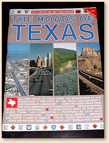 It's in the Tracker at all times and is on the "Must Have"
list for travel. It shows every county road and where each
crosses a creek, river, lake and flood control or life
retention ponds. I have gained access to some really
nice fishing holes through this book. Any state or
county maintained road has a 15 to 20 foot easement.
Any such road crossing a body of water is public access,
if the water is considered navigational. In Texas that
is a channel carrying water that is 30 feet across from
source to termination. Not the actual water but measured
from upper bank to upper bank. However not all landowners
abide by this and there are plenty of other places to go.
Don't argue with the landowners! It simply is not worth
the potential problems that could arise. In conjunction
with this is the book Fly-Fishing the Texas Hill
Country, which gives detailed public access
instructions to 14 different rivers all of which are
referenced by page and grid to, The Roads of Texas.
It's in the Tracker at all times and is on the "Must Have"
list for travel. It shows every county road and where each
crosses a creek, river, lake and flood control or life
retention ponds. I have gained access to some really
nice fishing holes through this book. Any state or
county maintained road has a 15 to 20 foot easement.
Any such road crossing a body of water is public access,
if the water is considered navigational. In Texas that
is a channel carrying water that is 30 feet across from
source to termination. Not the actual water but measured
from upper bank to upper bank. However not all landowners
abide by this and there are plenty of other places to go.
Don't argue with the landowners! It simply is not worth
the potential problems that could arise. In conjunction
with this is the book Fly-Fishing the Texas Hill
Country, which gives detailed public access
instructions to 14 different rivers all of which are
referenced by page and grid to, The Roads of Texas.
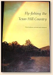
It also gives lodging, restaurants and general water
conditions. With these two books a fly-fisherman can
keep very busy for several years. However this is still
but a small piece of the pie.
For those of us who want to go beyond the "Known" places
there are different resources which are also available
for everyone's use. Of course there is always the whispered
"I know this great place. . .", but this is not a common
knowledge source. The Internet however is abundant with
information. For anyone who is interested in Texas fishing,
salt or freshwater, the single best starting source in my
experience has always been
www.tpwd.state.tx.us/ . The information found here is
excellent, both river and lake information is abundant
and easy to access. Fishing reports, water conditions
and access points are well mapped for all the State Parks
and links to any lakes that contain a web site for additional
maps.
In addition there are links to Internet sites that have
online Topographic Maps for viewing and in some cases
printing. One site I know of will allow you to select
maps for ordering and come as waterproof material so
streamside usage will not damage the maps. For those
who do not know, Topographic Maps or just simply known as,
"Topo Maps", give elevation grids as well as the usual
cartographical information. This gives a good indication
as to the steepness of the area to provide planning for
drift fishing, wading and hiking. They also can contain
hiking trails, fire roads and other means to show a path
to streams and ponds not normally shown on common road maps.
Below are listed sites that can get you to topo maps.
Some are viewed online while others are for ordering.
Have fun exploring.
www.topozone.com Topozone is
an excellent online resource with downloadable maps and links
to trail resources etc. and is my personal favorite. More:
The last thing I want to mention is the Global Positioning
System or GPS especially the portable downloadable mapping
ones. Of all the above-mentioned resources, this is by far
the most beneficial for me. No, I'm not worried about
getting lost but I use it on every single trip. Wherever
I do really well I mark it on the GPS. This gives me the
ability to track the movements of the fish throughout the
seasons. With notes like feeding top water or nymphing,
what fly is used and whether the fish are on beds or schooling.
All this saved on a computer for uploading and downloading.
I save the tracks on each trip to see the deviations if any,
in the river channel. This is especially useful when
re-visiting a river after a long absence or severe flooding.
But even more useful is the software that is available to
upload maps to the unit. Using downloadable topographic
map software for the GPS, I have found access to rivers,
creeks, ponds and flood retention reservoirs that have
produced some outstanding fishing. With the GPS I am
sure not to get lost on the initial first trip. Of these
areas, I have seen no one other than the local citizens.
In fact one area was a small park in another town that
I never knew about and the creek running through it produced
some really fine bass. Is it worthwhile? Yes, just look
at some of the places I have found.
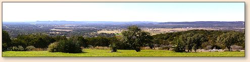
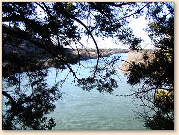
Overlooking the Colorado River basin in the Inks lake region.

From the above picture, turn around and the last thing
one would expect is a medieval castle. Yes, it's a
residence, all 195,000 square feet, with no tours but
that's a whole different story and it's not on any maps.
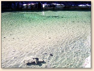
Cow Creek (above) has extremely clear waters. The rocks in
the foreground are under water. Cow Creek Rd. crosses
these waters 6 times offering several access points.
A beautiful private park can be found along the way
that anyone can use, again not on any maps.
Finally a parting shot from atop cliffs overlooking
the North San Gabriel entering Lake Georgetown.
The point of all this. . .there is no excuse not to
get out there and have some fun!
Next time, It's White Bass season and I've got pics,
flies and the story to go with them.
Until next time, Good Fishing!
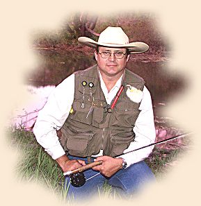
~ Hillfisher
|