ROAD TRIP
On Memorial Day, after we helped put out the American flags in our local park at 6 A M, we enjoyed a nice breakfast at our local truck stop and then hit the road for our first road trip since we got back to Montana.
The weather was marginal with a partly cloudy sky and a stiff breeze out of the south. The temperatures were in the mid-50’s and the weather man was promising rain by the afternoon. Everything here is very late. In the lower elevations the trees are just beginning to put out leaves, and most of the mountains are still completely covered with snow. Run off started on some of the major rivers early in May and then the weather turned cool and wet which shut off the run off. In some of the higher mountains we have been adding to the snow pack as recently as last week.
From Livingston we headed west toward Bozeman. Our first stop was the Madison River north of Bear Trap Canyon. The river was low and clear, but the wind was blowing hard out of the south. I think the weather retarded the crowds because there were only a few people along the river which is normally very crowded on this weekend. We made a stop at the mouth of the Bear Trap Canyon and there were a few caddis flies in the bushes and a couple anglers getting ready to launch their drift boats but otherwise it was real quiet.
Continuing south we passed through Ennis. Not much action in the self proclaimed Trout Capitol of Montana. We crossed the Madison River as we left town and the access site was devoid of cars. The river was still running clear with little sign of any run off. The Madison Range to the east and the Tobacco Roots and the Gravelly Range to the west were still clothed in snow. As we headed on south there was still low snow along the tops of the ridges just above the valley floor. Considering that the next day would be June 1st this low snow was a reminder of how late the spring is in coming here.
The road parallels the Madison but for much of the distance from Ennis to Quake Lake the river flows out of view of the road. Each time the road came close to the river we noticed that there were few people at any of the access sites. The stiff wind continued to blow out of the south and seemed to be increasing.
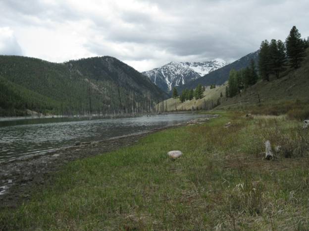
The upper end of Quake Lake – May 31, 2010
At Reynold’s Bridge there were a few more boat trailers but the water above Slide Inn was lacking any sign of anglers. As we topped the hill at the quake site Quake Lake stretched out before us. There were a few boats out on the lake which appeared to be about 3 feet below full pool. We stopped at Campfire Lodge and then we drove the access road along the Madison down to the head of Quake Lake. We parked at the parking lot at the end of the road and walked down toward the mouth of Beaver Creek where it enters the lake. The Quaking Aspen were just beginning to show some green and, except for some Glacier Lilies and yellow violets, the normal wildflowers that I would have expected to see this time of the year were just beginning to push up some green leaves.
We skirted the north Shore of Hebgen Lake, which also appeared to be about 3 feet below full pool. I noticed when we passed the dam that they appear to still be working on the structure that controls the release of water from the lake. This structure failed in August 2008 resulting in a considerable increase in the amount of water being released from the lake. On August 31st the flow in the Madison River below the dam increased from 850 cfs [cubic feet per second] at 12:30 pm to 3700 cfs at 2:15 pm. The discharge from the dam remained basically uncontrolled until September 21, 2008. Currently they are making major changes to the control structure in hopes of preventing a similar situation in the future.
The moisture that this area received in the last month has pushed the snowpack levels to near or slightly above average. The latest figures put the Madison Range at 96%, the Gallatin at 126%, and the Jefferson at 106%. The long range forecast is for a cool and wet June which bodes well for stream flows and cool water temperatures.
Turning north at the Duck Creek Y we drove through the western edge of Yellowstone National Park. Grayling Creek was clear and when we topped the hill we dropped into the top of the Gallatin drainage. The upper Gallatin was clear but when we passed Taylor Fork the river became dirty. There were no anglers in the Yellowstone portion of the Gallatin but we did see a couple anglers on the lower river. Mostly the river was being used by kayakers and rubber rafters.
Back home the Yellowstone River was running low and clear for this time of the year but there were only a few anglers testing the waters. The cool and rainy weather has apparently cooled the ardor of most of the local anglers.
As I write this the Yellowstone and most of the other rivers in this area have started to rise, and I think that the runoff has now official started. If you want to check the state of the major rivers in Montana you can log on to https://waterdata.usgs.gov/mt/nwis/current?type=flow which will give you an up to the minute report. One of these days I need to get out and wet a line myself.
Note: As of June 5, 2010 at 9:00 P.M. the Yellowstone at Livingston was running 23,900 cfs. Bank full is 8.5 feet and as of this date the river is running at 9.17 feet.